
Archive Record
Images
Metadata
Catalog Number |
2002.776.1 |
Object Name |
Map |
Scope & Content |
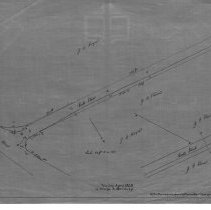
An 28 x 18" starched linen map showing the widening of Cross Street. Shows widening at corner of Andover Street (Route 114) and Prospect Street. Cross stree is next to the Northshore Mall. In 1889 Town Report, it states that $800 was appropriated for the work on Cross Street which included moving walls stones and earth and came to $815.06. Most likely this is a duplicate from the original that was done in the 19th century. There is a note that reads: "Surveyor's description notes with original plan" The map was traced by George A. Barnaby in April of 1928. Plan No. 24 |
Access Conditions |
Restricted to use in Sutton Room or Research Room. |
Physical characteristics |
Starched Linen Map |
Creator |
George A. Barnaby |
Title |
Plan of widening of Cross Street, Peabody, MA |
Level of description |
Item |
Copyrights |
All copyrights belong to the Peabody Institute Library, Peabody, MA |
Collection |
Local History Resource Center |
Pub Date |
1926 |
Size |
28 x 18" |
Subjects |
Peabody (Mass.)--History--Map |
Parent ObjectID |
2015.36.2 |