
Archive Record
Images
Metadata
Catalog Number |
2003.371.1.C |
Old ID number |
2003.371.3 |
Object Name |
Map |
Scope & Content |
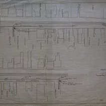
Plan shows where underground fire alarm system will be placed in and around Peabody Square. This map shows the area around Main Street. The streets include: Main Street; Wallis Street; Washington Street; Little's Lane; Park Street; Nichols Court and Mill Street. Property lines are not shown, but owners are. They include: Catherine T. O'Shea; National Bank; Heirs of Mayhew S. Clark; William F. Sawyer; Sarah Rogers; Frank Merrill; A.B. Clarke; the Universalist Church; S.H. Ware; Savings Bank; Henry L. Widden; Lucy Allen; W.F. Munroe; Joseph Jacobs; Bushby; E.H. Porter and Elliott. Vincent O'Keefe was the engineer who did the work on the map and the may was traced in May of 1929 by George A. Barnaby. Plan No. 220 Sheet No. 3 Total Sheets 4 |
Access Conditions |
Restricted to use in Sutton Room or Research Room. |
Creator |
Vincent P. O'Keefe |
Title |
Plan showing Proposed Underground Fire Alarm System in Peabody Square and Adjoining Streets. |
Level of description |
Item |
Copyrights |
All copyrights belong to the Peabody Institute Library, Peabody, MA |
Collection |
Local History Resource Center |
Pub Date |
1914 |
Size |
28 x 18" / 46 x 71.12 cm |
Subjects |
Peabody (Mass.)--History--Map(s) O'Shea, Catherine O'Shea Clark, Mayhew S. Sawyer, William F. Osborne Rogers, Sarah Merrill Frank Clarke, A. B. Ware, S. H. Whidden, Henry L. Allen, Lucy Munroe, W. F. Jacobs, Joseph Porter, E. H. |
Parent ObjectID |
2015.36.2 |
Relation |
Show Related Records... |