
Archive Record
Images
Metadata
Catalog Number |
2003.362.1 |
Old ID number |
2003.362 |
Object Name |
Map |
Scope & Content |
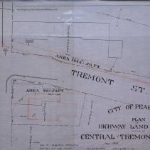
Plan shows proposed widening of Tremont Street and land and property to be taken by city. Property owned by people on plan do not appear in street directories for those years, but they are shown on the map and include: Prescott Cemetary; Eliza P. Osborne; Susan l. Ferguson and Elizabeth h. Cockburn. Frank Emerson, city engineer, did the survey in May of 1918 and the map was traced by George A. Barnaby in April of 1929. Plan No. 198 |
Access Conditions |
Restricted to use in Sutton Room or Research Room. |
Creator |
City of Peabody |
Title |
City of Peabody Plan of Highway Land taken at corner of Central and Tremont Streets. |
Level of description |
Item |
Copyrights |
All copyrights belong to the Peabody Institute Library, Peabody, MA |
Collection |
Local History Resource Center |
Pub Date |
1918 |
Size |
28 x 18" / 46 x 71.12 cm |
Subjects |
Peabody (Mass.)--History--Map(s) |