
Archive Record
Images
Metadata
Catalog Number |
2003.10.1 |
Object Name |
Map |
Scope & Content |
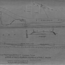
One 28 x 18" starched linen map shows the proposed road, extending off Walnut Street to Grove Street, Salem. The proposed new street is an extension of Walnut Street going to Grove Street, Salem. The Grove Street, Peabody is present day Howley Street. The map runs near Harmony Grove Cemetery. The Salem and Lawrence Brand Rail Road can been seen on the map running parallel to the canal and the proposed street. One can also see the elevation of the street. This is a duplicate of the orginal. It is unknown what happened to the original. The land was surveyed by Charles A. Putnam on September 26th, 1889. The map was traced from the original by George A. Barnaby in March of 1928. Plan No. 35 Section 1 |
Access Conditions |
Restricted to use in Sutton Room or Research Room. |
Physical characteristics |
Starched Linen Map |
Creator |
George A. Barnaby |
Title |
Plan of Proposed Street, Leading from Grove Street, Peabody to Grove Street, Salem. |
Level of description |
Item |
Copyrights |
All copyrights belong to the Peabody Institute Library, Peabody, MA |
Collection |
Local History Resource Center |
Pub Date |
1889 |
Size |
28 x 18" |
Subjects |
Peabody (Mass.)--History--Map(s) |
Parent ObjectID |
2015.36.2 |