
Archive Record
Images
Metadata
Catalog Number |
2003.14.2 |
Object Name |
Map |
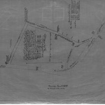
Scope & Content |
One 28 x 18" Starched Linen Map. A Plan of the location of a town way commencing near a large Elm Tree on land of Joseph Poor opposite the house of Benjamin Stevens and passing over land of said Poor to the Burial Ground, then by the Burial Ground to the Mill Dam, thus far 50 feet wide, then across the Mill Dam a distance of 371 feet, 30 feet wide, and then to the Main Street about 2 rods in width as made by the Selectmen of Danvers, and the following Petitions, viz. Sylvester Osborn Jr. Sept. 1837 Sylvester Osborn Jr. March 1838 Sylvester Osborn Jr. January 1839. Surveyed and Drawn by John W. Proctor. This is a duplicate of the orginal. The map was traced from the original by George A. Barnaby in March of 1928. Note that: Road to Andover is Central Street; the road to Boston is Washington Street Lane by the edge of the pond is Mill Street Road from Wallis house to Monumental Cemetery is Wallis Street and road leading from Elm tree to Wallis Street is Elm Street. Plan No. 39 |
Access Conditions |
Restricted to use in Sutton Room or Research Room. |
Physical characteristics |
Starched Linen Map |
Creator |
George A. Barnaby |
Title |
A Plan of the Location of a Town Way commencing near a large Elm Tree on Land of Joseph Poor opposite the House of Benjamin Stevens. |
Level of description |
Item |
Copyrights |
All copyrights belong to the Peabody Institute Library, Peabody, MA |
Collection |
Local History Resource Center |
Pub Date |
1839 |
Size |
28 x 18" |
Subjects |
Peabody (Mass.)--History--Map(s) |
Parent ObjectID |
2015.36.2 |