
Archive Record
Images
Metadata
Catalog Number |
2003.53.1 |
Object Name |
Map |
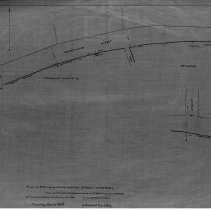
Scope & Content |
Shows proposed widening of Washington Street between the Franklink Osborn, Jr. and Stimpson properties. Allen's Road and and unknown road and way. This is a duplicate of the orginal. It is unknown what happened to the original. The land was surveyed by Charles A. Putnam on April 12th, 1883. The map was traced from the original by George A. Barnaby in March of 1928. One 28 x 18" Starched Linen Map. Plan No. 53 |
Access Conditions |
Restricted to use in Sutton Room or Research Room. |
Physical characteristics |
Starched Linen Map |
Creator |
George A. Barnaby |
Title |
Plan of portion of Washington Street, in Peabody, showing proposed widening at lands of Osborn and Stimpson. |
Level of description |
Item |
Copyrights |
All copyrights belong to the Peabody Institute Library, Peabody, MA |
Collection |
Local History Resource Center |
Pub Date |
1883 |
Size |
28 x 18" |
Subjects |
Peabody (Mass.)--History--Map(s) |
Parent ObjectID |
2015.36.2 |