
Archive Record
Images
Metadata
Catalog Number |
2002.708.1.I |
Object Name |
Map |
Scope & Content |
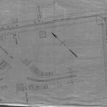
One 28 x 18" map, Plan 1, Sheet No. 9 of the plans showing the proposed horse rail road route, from Lynn To Peabody in 1883 The map was traced by George A. Barnaby in 1929. Sheet 9 shows Washington Street meeting up with Main Street. On main street is the Naumkeag Street Railway that conitunes down Main Street and looks like it does branch off onto Washington Street. The branch is near the Lexington Monument that is at the Main and Washington intersection. The house shown on Main Street is the Sutton Home that looks towards Wallis Street. A second images shows Main Street Meeting at Peabody Square where Lowell, Central, Foster and Main Street all meet. The South Church is still shown on the map. |
Access Conditions |
Restricted to use in Sutton Room. |
Creator |
George A. Barnaby |
Title |
Plans Showing Proposed Horse Rail Road Route, From Lynn To Peabody. 1883. |
Level of description |
Item |
Copyrights |
All copyrights belong to the Peabody Institute Library, Peabody, MA |
Collection |
Local History Resource Center |
Pub Date |
1883 |
Size |
28 x 18" |
Subjects |
Peabody (Mass.) - Maps |
Parent ObjectID |
2015.36.2 |