
Archive Record
Images
Metadata
Catalog Number |
2003.358.1.F |
Old ID number |
2003.358.6 |
Object Name |
Map |
Scope & Content |
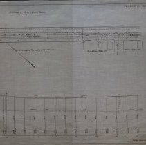
Construction plans by state for Margin Street which became a state highway in 1914. The plan shows Margin Street and Holly Street and the location of 30" water pipe of the Salem Water Works and a 6" water pipe for Peabody running under the road. This map also shows the 8" sewer pipe. The properties of Maria Cullan and Katherine Wallace is shown on the map. The bottom of the map shows the elevation and grade of the road. O'Connell Real Estate Trust is on the Map as well. The state creating a state highway on Margin Street in Peabody was controversial at the time. Before state road was built, the public works department made the connections with the water pipes from main in street to avoid digging up new macadam road. The cost of construction at the time was $18,000, half of which was assumed by the state, a quarter to be assumed by county and another quarter by the town of Peabody, though city records indicate that $9,000 was paid by Peabody in 1914 for the work on Margin Street, though the Department of Public Works indicated that the County did pay $4500. First Assistant Engineer A.W. Lois did the survey on February 11, 1913. It is unknown the location or the original, but this map was traced by George A. Barnaby in December of 1928. Plan No. 181 Sheet No. 3 Section No.2 Note: Total Sheets , 7 |
Access Conditions |
Restricted to use in Sutton Room or Research Room. |
Physical characteristics |
Starched Linen Map |
Creator |
Massachusetts Highway Commission |
Other Creators |
George A. Barnaby |
Title |
Plan and Profile of Proposed State Highway in Peabody |
Level of description |
Item |
Copyrights |
All copyrights belong to the Peabody Institute Library, Peabody, MA |
Collection |
Local History Resource Center |
Pub Date |
1913 |
Size |
18" x 28" / 46 x 71.12 cm |
Subjects |
Peabody (Mass.)--History--Map(s) |
Parent ObjectID |
2015.36.2 |
Relation |
Show Related Records... |