
Archive Record
Images
Metadata
Catalog Number |
2003.385.2 |
Object Name |
Map |
Scope & Content |
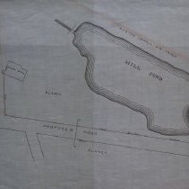
Plan shows proposed new road going over Essex Railroad tracks to Endicott Street. One road comes off this new road, heading south to Lowell Street and another comes off, heading north. Mill Pond is also in plan between Blaney property and Endicott Street. The road coming from the railroad tracks and connecting to Endicott Street is the present day Warren Street. The street coming off Warren and heading south to Lowell Street is Crowninshield Street, the other street coming off to go north is the present day Berry Street. Peabody Press states that Stephen Blaney owned the Crowninshield House which is confirmed on this map. This building was used originally by the Crowninshields for the manufacture of cloth, later bought by Stephen Blaney (date unknown). In 1877, Blaney with other businessmen to turn the building into a shoe factory, which was done in 1878 and later became the site of the A. C. Lawrence Leather Co. Charles A. Putnam was the person who did the survey. The original map may have been lost because this is copy of the original that was traced by George A. Barnaby in May of 1929. Plan No. 233 Sheet No. 2 Note: Total Sheets 4 |
Access Conditions |
Restricted to use in Sutton Room or Research Room. |
Creator |
Charles Appleton Putnam |
Other Creators |
George A. Barnaby |
Title |
Plan and Profiles of Proposed New Roads in Peabody |
Level of description |
Item |
Copyrights |
All copyrights belong to the Peabody Institute Library, Peabody, MA |
Collection |
Local History Resource Center |
Pub Date |
1877 |
Size |
46 x 71.12 cm |
Subjects |
Peabody (Mass.)--History--Map(s) |
Parent ObjectID |
2015.36.2 |