
Archive Record
Images
Metadata
Catalog Number |
2002.708.1.H |
Object Name |
Map |
Scope & Content |
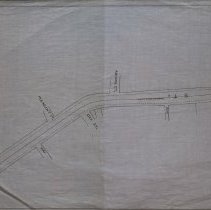
One 28 x 18" map, Plan 1, Sheet No. 7 that shows the plans for a proposed horse rail road route, From Lynn To Peabody. 1883. The map shows Washington Place; Way; Aborne Street; Oak Street; Pleasant Street and Way. The map shows the location of Cistern on Washington Street The map was traced by George A. Barnaby in 1929. it is unclear the location of the original. Point F on Sction No. 7 |
Access Conditions |
Restricted to use in Sutton Room or Research Room. |
Creator |
George A. Barnaby |
Title |
Plans Showing Proposed Horse Rail Road Route, From Lynn To Peabody. 1883. |
Level of description |
Item |
Copyrights |
All copyrights belong to the Peabody Institute Library, Peabody, MA |
Collection |
Local History Resource Center |
Pub Date |
1883 |
Size |
28 x 18" |
Subjects |
Peabody (Mass.)--History--Map(s) |
Parent ObjectID |
2015.36.2 |