
Archive Record
Images
Metadata
Catalog Number |
2002.765.1 |
Object Name |
Map |
Scope & Content |
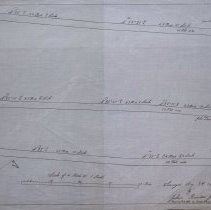
One 28 x 18" Starched Linen map showing proposed roads laid out between Walnut and Tremont Street. The land was surveyed on August 8th, 1851 and map created in February of 1928 by Joshua Buxton, Jr. There are notes about the location of the roads and issues with the plan. Could be Union, Harris and Fulton Streets. |
Access Conditions |
Restricted to use in Sutton Room or Research Room. |
Physical characteristics |
Starched linen map. |
Creator |
George A. Barnaby |
Title |
Plan Showing Proposed Roads Between Walnut And Tremont Streets. |
Level of description |
Item |
Copyrights |
All copyrights belong to the Peabody Institute Library |
Collection |
Local History Resource Center |
Pub Date |
1851 |
Size |
28 x 18" |
Subjects |
Peabody (Mass.)--History--Map Peabody (Mass.)--Streets |
Parent ObjectID |
2015.36.2 |