
Archive Record
Images
Metadata
Catalog Number |
2003.131.1 |
Object Name |
Map |
Scope & Content |
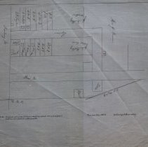
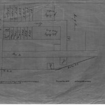
Map shows lane between Pine Street and Newbury Street. The lane is now called Broad Street. Original drawing all torn and dilapidated. It was a pencil sketch and indexed as Broad Street. Original drawn before 1889 when Broad Street received its name. This is a duplicate of the orginal. It is unknown what happened to the original. The map was traced from the original by George A. Barnaby in December of 1928. One 28 x 18" Starched Linen Map. Plan No. 71 |
Access Conditions |
Restricted to use in Sutton Room or Research Room. |
Physical characteristics |
Starched Linen Map. |
Creator |
George A. Barnaby |
Title |
Map of Lane later known as Broad Street. |
Level of description |
Item |
Copyrights |
All copyrights belong to the Peabody Institute Library, Peabody, MA |
Collection |
Local History Resource Center |
Pub Date |
Before 1889 |
Size |
28 x 18" |
Subjects |
Peabody (Mass.)--History--Map(s) |
Parent ObjectID |
2015.36.2 |