
Archive Record
Images
Metadata
Catalog Number |
2003.412.1.B |
Object Name |
Map |
Scope & Content |
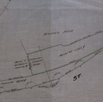
Plan shows the widening of a dangerous curve on Lynn Street. The P. H. Mosher listed as City Engineer may be from Revere as the Peabody Paragraph, August 31, 1928, attached as an image, describes the work to begin being done by a Revere contractor, T. F. McCarthy. P.H. Mosher the City Engineer, did the survey of the land. It is unknown where the location of the original is. This may was traced by George A. Barnaby in July of 1929. Plan No. 250 Shection No. 2 Total Sheets 2 |
Access Conditions |
Restricted to use in Sutton Room or Research Room. |
Physical characteristics |
Starched Linen Map |
Creator |
George A. Barnaby |
Title |
Plan of Land Taken by the City on Lynn Street, Peabody, Mass. |
Level of description |
Item |
Copyrights |
All copyrights belong to the Peabody Institute Library, Peabody, MA |
Collection |
Local History Resource Center |
Pub Date |
1928 |
Size |
46 x 71.12 cm |
Subjects |
Peabody (Mass.)--History--Map(s) Donovan, Harry F. Donovan, Willard N. Swan, Carrie B. Legro, E. F. |
Parent ObjectID |
2015.36.2 |