
Archive Record
Images
Metadata
Catalog Number |
2002.769.1 |
Object Name |
Map |
Scope & Content |
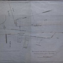
One 28 x 18" starched linen map shows Aborn Street merging into unnamed street, which could be Sutton Street, but more research is needed. Property included on the Street is Mrs. Putnam; Ayers; William Sutton; G. Wright; S. Fernald house. It is unknown who did the survey but the alterations in location of same is dated April 21, 1859 and the map was traced in January of 1928 by George A. Barnaby. Plan No. 17 |
Access Conditions |
Restricted to use in Sutton Room or Research Room. |
Creator |
George A. Barnaby traced map Jan. 1928 |
Title |
Plan, of portion of the Road, showing the proposed alterations in location of same, April 21st, 1859. |
Level of description |
Item |
Copyrights |
All copyrights belong to the Peabody Institute Library |
Collection |
Local History Resource Center |
Pub Date |
1859 |
Size |
28 x 18" |
Subjects |
Peabody (Mass.)--History--Map Peabody (Mass.)--Streets |
Parent ObjectID |
2015.36.2 |