
Archive Record
Images
Metadata
Catalog Number |
2002.768.1 |
Object Name |
Map |
Scope & Content |
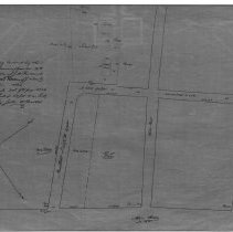
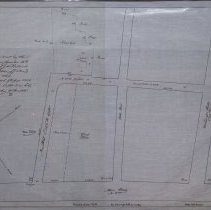
One 28 x 18" starched linen map shows area around school district number one, 1845. The mape shows that a new street was to be added. That new street became Pierpont Street. Streets that still exist include Wasington, Main, Holden and Sewall Street. The schools property is shown on the map. |
Access Conditions |
Restricted to use in Sutton Room or Research Room. |
Creator |
George A. Barnaby traced map June 1929 |
Title |
A Plan of a Way laid out by the Selectmen of Danvers, December 20th, 1825, amended September 1846. |
Level of description |
Item |
Copyrights |
All copyrights belong to the Peabody Institute Library |
Collection |
Local History Resource Center |
Pub Date |
1845 |
Size |
28 x 18" |
Subjects |
Peabody (Mass.)--Streets Peabody (Mass.)--Schools--History--Map |
Parent ObjectID |
2015.36.2 |