
Archive Record
Images
Metadata
Catalog Number |
2002.729.2 |
Object Name |
Map |
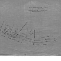
Scope & Content |
Plan detailing Aborn Street at the Peabody/Salem Border. Land was surrveyed in July of 1883Charles A. Putnam surveyor. The map was traced in January of 1928 by George A. Barnaby. The map is 18 x 28" detailing property aroundAborn Street. Included on the mpa is the Sutton Estate; Peabody and Salem border/ Holman house; Jacobs House and Cotter house. Plan No. 6, Sect. B. |
Access Conditions |
Restricted to use in Sutton Room or Research Room. |
Physical characteristics |
Starched linen map. |
Creator |
George A. Barnaby |
Title |
Plan of Portion of Aborn Street, In Salem and Peabody. |
Level of description |
Item |
Copyrights |
All copyrights belong to the Peabody Institute Library. |
Collection |
Local History Resource Center |
Pub Date |
1928 |
Size |
28 x 18" |
Subjects |
Peabody (Mass.) - Maps Peabody (Mass.) - Boundaries |
Parent ObjectID |
2015.36.2 |