
Archive Record
Images
Metadata
Catalog Number |
2002.708.1.F |
Object Name |
Map |
Scope & Content |
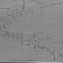
One 28 x 18" map, Plan 1, Sheet No. 6 of the plans showing the proposed horse rail road route, from Lynn To Peabody in 1883 The map was traced by George A. Barnaby in 1929. Sheet 6 now focuses on Washington Street. One view is of Washington Street meeting with High Street and Allens Lane with the cemetery next to Allens Lane. There is a hotel next to High Street. The second view is of Washington Street meeting with Foster Street and Dustin Street; Swampscott Ave. and two way streets. It also looks like there is property owned by S. Blaney next to Dustin Street. |
Access Conditions |
Restricted to use in Sutton Room. |
Creator |
George A. Barnaby |
Title |
Plans Showing Proposed Horse Rail Road Route, From Lynn To Peabody. 1883. |
Level of description |
Item |
Copyrights |
All copyrights belong to the Peabody Institute Library, Peabody, MA |
Collection |
Local History Resource Center |
Pub Date |
1883 |
Size |
28 x 18" |
Subjects |
Peabody (Mass.) - Maps |
Parent ObjectID |
2015.36.2 |