
Archive Record
Images
Metadata
Catalog Number |
2003.23.2 |
Object Name |
Map |
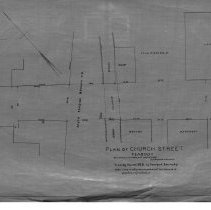
Scope & Content |
This 28 x 18" starched linen map shows the newly laid out Church Street. Other important parts of the map include the location of the South Reading Branch Railroad; a brook and its culvert. Property includes C.C. Pike and R.C. Nelson among others. This is a duplicate of the orginal. It is unknown what happened to the original. The land was surveyed by Charles A. Putnam on March 30, 1893. The map was traced from the original by George A. Barnaby in March of 1928. Plan No. 42 |
Access Conditions |
Restricted to use in Sutton Room or Research Room. |
Physical characteristics |
Starched Linen. |
Creator |
George A. Barnaby |
Title |
Plan of Church Street, Peabody. |
Level of description |
Item |
Copyrights |
All copyrights belong to the Peabody Institute Library, Peabody, MA |
Collection |
Local History Resource Center |
Pub Date |
1893 |
Size |
28 x 18" |
Parent ObjectID |
2015.36.2 |