
Archive Record
Images
Metadata
Catalog Number |
2003.396.1.B |
Old ID number |
2003.396.2 |
Object Name |
Map |
Scope & Content |
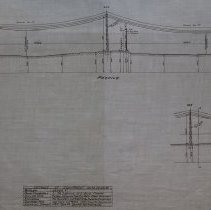
Maps is a profile of the plans for electric transmission lines near the junction of Lowell Street and Newbury Street. The map Includes details of equipment used. The map and suvey was prepared by Charles H. Tenney and Co. who were engineers in Boston. The Date of the map is 1923 with revisions takeing place on October 19, 1923. It is unknown the location of the original. This map was retraced by George A. Barnaby in July of 1929. Plan No. 239-A Section No. 1 Total Sheets 2 |
Access Conditions |
Restricted to use in Sutton Room or Research Room. |
Creator |
Eastern Mass. Electric Co. |
Title |
Eastern Mass. Electric Co. Location of Transmission Line Across Lowell Street, Peabody, Mass. Showing Steel Towers. |
Level of description |
Item |
Copyrights |
All copyrights belong to the Peabody Institute Library, Peabody, MA |
Collection |
Local History Resource Center |
Pub Date |
1923 |
Size |
46 x 71.12 cm |
Subjects |
Peabody (Mass.)--History--Map(s) |
Parent ObjectID |
2015.36.2 |