
Archive Record
Images
Metadata
Catalog Number |
2003.368.18 |
Object Name |
Map |
Scope & Content |
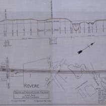
Plan shows location of the Boston & Eastern Electric Railroad in Revere. The top of the map shows the elevation and grade of the proposed railroad. The bottom is a map that shows: Eastern Avenue; True Street; National Fire Proofing Company; School Street; Mountain Avenue; Central Avenue; Sprague Street; Winthrop Avenue and the old route to Sullivan Square. There is a note on the map that reads: "That portion of the rounte shown on plans A1885, A1895, A1965, A1955, A1945, A1915, A1905, A 1925, A 1935, A1975, A1985, A1995 and A2005 filed on or about October 14, 1907 superseces that portion of the route shown on plan A1549, A1539, A1529, A1519, and A1509 filed on or about April 29, 1907, in sofar as the latter portion of route lies westerly of station 633+00 situated near Eastern Avenue in the town of Revere." The note was added on March 2, 1908. The survey was done by John H. Bickford a Civil and Electrical Engineer who was located at 110 State Street in Boston. The map was first drawn by H.A.S. on October 1, 1906; The map was then traced by H.A.S. at an unknown date. This may be a duplicate because the map was retraced by George A. Barnaby in June of 1929. Plan No. 217 Sheet No. 14 Total sheets 20 |
Access Conditions |
Restricted to use in Sutton Room or Research Room. |
Creator |
John H. Bickford |
Other Creators |
George A. Barnaby |
Title |
Boston and Eastern Electric Railroad -- Revised Route -- 12 1/2 Miles from Beverly |
Level of description |
Item |
Copyrights |
All copyrights belong to the Peabody Institute Library, Peabody, MA |
Collection |
Local History Resource Center |
Pub Date |
1907 |
Size |
46 x 71.12 cm |
Subjects |
Revere (Mass.) Revere (Mass.)--Maps Boston and Eastern Electric Railroad |
Parent ObjectID |
2015.36.2 |
Relation |
Show Related Records... |