
Archive Record
Images
Metadata
Catalog Number |
2003.12.2 |
Object Name |
Map |
Scope & Content |
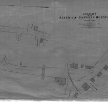
This 28 x 18" starched linen map shows route South Reading Railroad going though Peabody Square with the Essex Railroad and Lowell Railroad crossing Central Street. This is a duplicate of the orginal. It is unknown what happened to the original. The land was surveyed by Charles A. Putnam in January of 1863. The map was traced from the original by George A. Barnaby in February of 1928. Plan No. 37 Section B |
Access Conditions |
Restricted to use in Sutton Room or Research Room. |
Physical characteristics |
Starched Linen Map |
Creator |
George A. Barnaby |
Title |
Location of the Salem and South Danvers Horse Rail Road In South Danvers. |
Level of description |
Item |
Copyrights |
All copyrights belong to the Peabody Institute Library, Peabody, MA |
Collection |
Local History Resource Center |
Pub Date |
1863 |
Size |
28 x 18" |
Subjects |
Peabody (Mass.)--History--Map(s) |
Parent ObjectID |
2015.36.2 |