
Archive Record
Images
Metadata
Catalog Number |
2002.708.1.B |
Object Name |
Map |
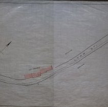
Scope & Content |
One 28 x 18" map, Plan 1, Sheet No. 2 of thepPlans showing the proposed horse rail road route, from Lynn To Peabody in 1883 The map was traced by George A. Barnaby in 1929. Sheet 2 looks at Lynn Street and the Ice Houses along Lynn Street. |
Access Conditions |
Restricted to use in Sutton Room or Research Room. |
Creator |
George A. Barnaby |
Title |
Plans Showing Proposed Horse Rail Road Route, From Lynn To Peabody. 1883. |
Level of description |
Item |
Copyrights |
All copyrights belong to the Peabody Institute Library, Peabody, MA |
Collection |
Local History Resource Center |
Pub Date |
1883 |
Size |
28 x 18" |
Subjects |
Peabody (Mass.) - Maps |
Parent ObjectID |
2015.36.1 |