
Archive Record
Images
Metadata
Catalog Number |
2003.364.1 |
Object Name |
Map |
Scope & Content |
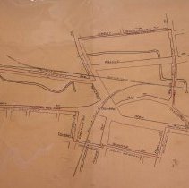
Plan shows proposed Fire Limits in and around Peabody Square. East to west, from Wallis Street to Sawyer Street and south to north, from Summer Street to Hardy Street. The tracks for the Boston & Maine Railroad (South Reading Branch) are also shown on the map and run through the square. The Main Boston & Maine Railroad runs throuigh two streets one of which is Wallis Street. It is unknow who did the the survey, but the plan was adopted on April 10, 1916. The map was then traced by George A. Barnaby in May of 1929 |
Access Conditions |
Restricted to use in Sutton Room or Research Room. |
Creator |
City of Peabody |
Title |
Town of Peabody Plan Showing Proposed Fire Limits |
Level of description |
Item |
Copyrights |
All copyrights belong to the Peabody Institute Library, Peabody, MA |
Collection |
Local History Resource Center |
Pub Date |
1916 |
Size |
21" x 36" |
Subjects |
Peabody (Mass.)--History--Map(s) Peabody (Mass.)--Streets |
Parent ObjectID |
2015.36.2 |