
Archive Record
Images
Metadata
Catalog Number |
2003.8.1 |
Object Name |
Map |
Scope & Content |
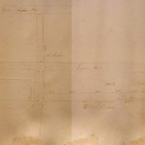
This 13" x 28 1/2" paper map shows Harris Street, English Street and Union Streets between Walnut and Tremont Streets. It should be noted that English Street in map is present day Paleologos Street. Though on map it appears as Clerk's Factory, it was Clark's Factory, run by Alexander B. Clark, a Morocco Manufacturer. The map was made sometime before 1882. It is unknown who the surveyor or creator of the map was. |
Access Conditions |
Restricted to use in Sutton Room or Research Room. |
Physical characteristics |
Starched Linen Map |
Creator |
George A. Barnaby |
Title |
Plan of Streets between Tremont and Walnut Street, Peabody |
Level of description |
Item |
Copyrights |
All copyrights belong to the Peabody Institute Library, Peabody, MA |
Collection |
Local History Resource Center |
Pub Date |
Before 1882 |
Size |
13" x 28 1/2" |
Subjects |
Peabody (Mass.)--History--Map(s) |
Parent ObjectID |
2015.36.2 |