
Archive Record
Images
Metadata
Catalog Number |
2002.774.1 |
Object Name |
Map |
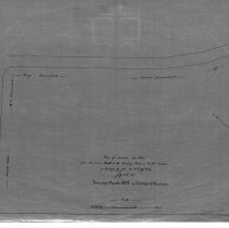
Scope & Content |
One 28 x 18" starched linen map of a proposed new road from Gardner's Brook to Reading Road. John H. Nichols was the surveyor, which was completed on July 30th 1840 and the map was traced in March of 1928 by George A. Barnaby. |
Access Conditions |
Restricted to use in Sutton Room or Research Room. |
Physical characteristics |
Starched Linen Map |
Creator |
George A. Barnaby |
Title |
Plan of proposed new road from Gardner's Brook to Reading Road. |
Level of description |
Item |
Copyrights |
All copyrights belong to the Peabody Institute Library, Peabody, MA |
Collection |
Local History Resource Center |
Pub Date |
July 30, 1840 |
Size |
28 x 18" |
Subjects |
Peabody (Mass.)--History--Map |
Parent ObjectID |
2015.36.2 |