
Archive Record
Images
Metadata
Catalog Number |
2016.36.19 |
Object Name |
Blueprint |
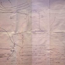
Scope & Content |
A topographic maps of the land where the old and new West Branch Library is. The map was created by the Department of Public Services from circa 1988. In the 1988 plans were started to look at building a new West Branch Library on the same piece of property that the old one sat on. An agreement and fessability study was done in 1988 along with plans and City Council approval. In late 1988 the groundbreaking took place. By February of 1989 the West Branch would close as the construction of the new building would not allow for the old one to remain open. |
Access Conditions |
Restricted to use in Sutton Room or Research Room. |
Creator |
Interact Archiecture Construction Management |
Title |
Topographys Plan of Peabody Institute Library West Branch |
Level of description |
Item |
Copyrights |
All copyrights belong to the Peabody Institute Library, Peabody, MA |
Collection |
Local History Resource Center |
Pub Date |
ca, 1989 |
Size |
24" x 36" |
Subjects |
Peabody Institute (Peabody, Mass.)--Construction or Blueprints Peabody Institute (Peabody, Mass.)--History Peabody Institute (Peabody, Mass.)--West Branch Library |
Parent ObjectID |
2014.31.1 |