
Archive Record
Images
Metadata
Catalog Number |
2003.385.4 |
Object Name |
Map |
Scope & Content |
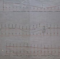
Profile of Centre Line of Proposed Road from Lowell St., Central St., to Endicott St Charles A. Putnam was the engineer who did the survey. The original map may have been lost because this is copy of the original that was traced by George A. Barnaby in September of 1929. Plan No. 225 Note: Total Sheets 1 Plan No. 233 Sheet No. 4 Total Sheets 4 |
Access Conditions |
Restricted to use in Sutton Room or Research Room. |
Creator |
Charles Appleton Putnam |
Title |
Plan and Profiles of Proposed New Roads in Peabody |
Level of description |
Item |
Copyrights |
All copyrights belong to the Peabody Institute Library, Peabody, MA |
Collection |
Local History Resource Center |
Pub Date |
1877 |
Size |
46 x 71.12 cm |
Subjects |
Peabody (Mass.)--History--Map(s) |
Parent ObjectID |
2015.36.2 |