
Archive Record
Images
Metadata
Catalog Number |
2003.392.1 |
Object Name |
Map |
Scope & Content |
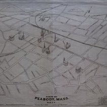
Map shows the streets and major landmarks of the town in the year 1877. English Street on map is present day Paleologos Street. Love Lane on map is present day Barry Street. Osborn Street on map is present day Collins Street which was extended at a later time. The map references: Peabody Institute & Eben Dale Sutton Library; High School; Public School; Town Hall and Clerk's Office; Post Office; South Danvers Mutual Fire Insurance Company; South Congregational Church; First Baptist Church; Episcopal Church; First Methodist Church; First Universalist Church; First Unitarian Church and Saint John's Roman Catholic Church. The map was created by Howard Heston Bailey and James Compton Hazen of Boston. Plan No. 237 |
Access Conditions |
Restricted to use in Sutton Room or Research Room. |
Creator |
Howard Heston Bailey & James Compton Hazen |
Title |
View of Peabody, Mass. 1877 |
Level of description |
Item |
Copyrights |
All copyrights belong to the Peabody Institute Library, Peabody, MA |
Collection |
Local History Resource Center |
Pub Date |
1877 |
Size |
46 x 71.12 cm |
Subjects |
Peabody (Mass.)--History--Map(s) |
Parent ObjectID |
2015.36.2 |