
Archive Record
Images
Metadata
Catalog Number |
2003.368.3 |
Object Name |
Map |
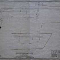
Scope & Content |
Plan shows location of the Boston and Eastern Electric Railroad in Boston. This is a revised route (Atlantic Avenue section). The map shows: India Square; Milk Street; Central Street; Atlantic Avenue and Central Wharf. The survey was done by John H. Bickford a Civil and Electrical Engineer who was located at 110 State Street in Boston. The map was first drawn by H.A.S. on October 1, 1906; The map was then traced by H.A.S. at an unknown date. This may be a duplicate because the map was retraced by George A. Barnaby in June of 1929. Plan No. 217 Sheet No. 2 Section No. 1 Total sheets 20 |
Access Conditions |
Restricted to use in Sutton Room or Research Room. |
Creator |
John H. Bickford |
Title |
Boston and Eastern Electric Railroad -- Revised Route -- Atlantic Ave. Section |
Level of description |
Item |
Copyrights |
All copyrights belong to the Peabody Institute Library, Peabody, MA |
Collection |
Local History Resource Center |
Pub Date |
1906 |
Size |
18" x 28" |
Subjects |
Boston and Eastern Electric Railroad Boston (Mass.) |
Parent ObjectID |
2015.36.2 |
Relation |
Show Related Records... |