
Archive Record
Images
Metadata
Catalog Number |
2003.27.1 |
Object Name |
Map |
Scope & Content |
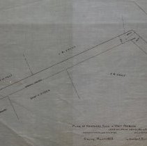
Plans for a proposed road that would connect Newbury Street (US Route 1) and Pint Street. At the time the road was unnamed but it now called Broad Street. Property on this map includes: Joseph Brown's Estate; J.B. Kelly; DCharles W. Felt; Thomas O'Donnel and Daniel A. Sheen among other properties. The map is 28 x 18" on starched linen paper. This is a duplicate of the orginal. It is unknown what happened to the original. The land was surveyed by Charles A. Putnam on March 6th, 1886. The map was traced from the original by George A. Barnaby in March of 1928. Plan No. 45 |
Access Conditions |
Restricted to use in Sutton Room or Research Room. |
Physical characteristics |
Starched Linen. |
Creator |
George A. Barnaby |
Title |
Plan of Proposed Road in West Peabody, Leading from Newbury To Pine Streets. |
Level of description |
Item |
Copyrights |
All copyrights belong to the Peabody Institute Library, Peabody, MA |
Collection |
Local History Resource Center |
Pub Date |
1886 |
Size |
28 x 18" |
Subjects |
Peabody (Mass.)--History--Map(s) |
Parent ObjectID |
2015.36.2 |