
Archive Record
Images
Metadata
Catalog Number |
2003.386.1.B |
Object Name |
Map |
Scope & Content |
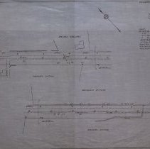
Map shows the state plan for Andover Street to become a state highway. Plan No. 2 is at the Peabody/Danvers boundary. The map includes locations of culverts and guard rails. In April 9, 1920 Peabody Paragraph, it states that the cost of water pipe extension on Andover Street would be $3,000 and that the pipe would be installed without disturbing the new state road on the Andover turnpike to be built in Peabody. The Brigham Estate on the plan is in Danvers and had been owned by George M. Brigham with his wife Lydia. He was a farmer living at 145 Sylvan Street. In addition, the map shows the property of Henry Tippert and Daniel Collins and Manuel Caton. The survey was done by the Commonwealth of Massachusetts in 1920. It is unknown what happened to the original. This copy was traced by George A. Barnaby in May of 1929. Plan No. 235 Sheet No. 2 Note: Total Sheets, 3 |
Access Conditions |
Restricted to use in Sutton Room or Research Room. |
Creator |
Commonwealth of Massachusetts |
Title |
Plan of Road in the City of Peabody, Essex County, Laid Out As A State Highway by the Department of Public Works |
Level of description |
Item |
Copyrights |
All copyrights belong to the Peabody Institute Library, Peabody, MA |
Collection |
Local History Resource Center |
Pub Date |
1920 |
Size |
46 x 71.12 cm |
Subjects |
Peabody (Mass.)--History--Map(s) |
Parent ObjectID |
2015.36.2 |