
Archive Record
Images
Metadata
Catalog Number |
2003.1.2 |
Object Name |
Map |
Scope & Content |
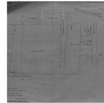
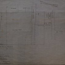
This 28 x 18" starched linen map showing homes in relation to extension for an extension of Bowditch Court. The land was surveyed in 1886 by Andrew Nichols. This is a duplicate from the original that was traced by George A. Barnaby in March of 1928. The maps shows Warren Street; Jacobs Street and Ash Street. Property on the map includes Heirs of Joshua Buxton; J. Buxton; Warren Five Cents Savings Bank; Charles G. Folsom; William Bushby;and George Crowninshield property. The Boston and Main Railroad is also represented on the map. Plan No. 26 Scetion 1 |
Access Conditions |
Restricted to use in Sutton Room or Research Room. |
Physical characteristics |
Starched Linen Map |
Creator |
George A. Barnaby |
Title |
Plan Showing Proposed Extension of Bowditch Court |
Level of description |
Item |
Copyrights |
All copyrights belong to the Peabody Institute Library, Peabody, MA |
Collection |
Local History Resource Center |
Pub Date |
1886 |
Size |
28 x 18" |
Subjects |
Peabody (Mass.)--History--Map |
Parent ObjectID |
2015.36.2 |