
Archive Record
Images
Metadata
Catalog Number |
2002.709.1 |
Object Name |
Map |
Scope & Content |
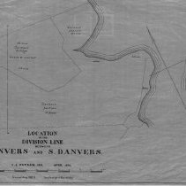
One 28 x 18" Starched Linen Map. Plan 2. Sheet No. 2 One 28 x 18" map, Plan 2, Sheet No. 1 of the plans showing the location Of The Division Line Between Danvers And South Danvers fin 1856. The map was traced by George A. Barnaby in 1929. Sheet 1 looks the location of J.S. Leavitt Woodland; Gardner Pasture at 16 acres and the Gardner tillage at 5 acres. |
Access Conditions |
Restricted to use in Sutton Room or Research area. |
Creator |
George A. Barnaby |
Title |
Location Of The Division Line Between Danvers And S. Danvers |
Level of description |
Item |
Copyrights |
All copyrights belong to the Peabody Institute Library |
Collection |
Local History Resource Center |
Pub Date |
1856 |
Size |
28 x 18" |
Subjects |
Peabody (Mass.) - Boundaries Peabody (Mass.) - Maps |
Parent ObjectID |
2015.36.2 |