
Archive Record
Images
Metadata
Catalog Number |
2003.368.13 |
Object Name |
Map |
Scope & Content |
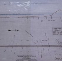
Plan shows location of the Boston and Eastern Electric Railroad in Boston. The top of the map shows the elevation and along the water and land. The botton shows the revised route of the railroad. The map shows two private ways; mud flats and Chelsea River. The survey was done by John H. Bickford a Civil and Electrical Engineer who was located at 110 State Street in Boston. The map was first drawn by H.A.S. on October 1, 1906; The map was then traced by H.A.S. at an unknown date. This may be a duplicate because the map was retraced by George A. Barnaby in June of 1929. Plan No. 217 Sheet No. 10 Total sheets 20 |
Access Conditions |
Restricted to use in Sutton Room or Research Room. |
Creator |
John H. Bickford |
Other Creators |
George A. Barnaby |
Title |
Boston and Electric Railroad -- Revised Route -- 13 1/2 Miles from Beverly |
Level of description |
Item |
Copyrights |
All copyrights belong to the Peabody Institute Library, Peabody, MA |
Collection |
Local History Resource Center |
Pub Date |
1907 |
Size |
18" x 28" |
Subjects |
Boston (Mass.) Boston (Mass.)--Maps Boston and Eastern Electric Railroad |
Parent ObjectID |
2015.36.2 |
Relation |
Show Related Records... |