
Archive Record
Images
Metadata
Catalog Number |
2003.52.1 |
Object Name |
Map |
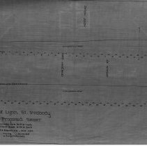
Scope & Content |
Plan shows where sewer would be placed in relation to streets for Lynn Street. This is a duplicate of the orginal. It is unknown what happened to the original. The land was surveyed by Charles A. Putnam on June of 1892. The map was traced from the original by George A. Barnaby in March of 1928. Horizontal scale - 60 feet to an inch Vertical scale - 10 feet to an inch One 28 x 18" Starched Linen Map. ' Plan No. 52 |
Access Conditions |
Restricted to use in Sutton Room or Research Room. |
Physical characteristics |
Starched Linen Map |
Creator |
George A. Barnaby |
Title |
Profile Of Lynn Street, Peabody, for Proposed Sewer. |
Level of description |
Item |
Copyrights |
All copyrights belong to the Peabody Institute Library, Peabody, MA |
Collection |
Local History Resource Center |
Pub Date |
1892 |
Size |
28 x 18" |
Subjects |
Peabody (Mass.)--History--Map(s) |
Parent ObjectID |
2015.36.2 |