
Archive Record
Images
Metadata
Catalog Number |
2008.50.4 |
Object Name |
Map |
Scope & Content |
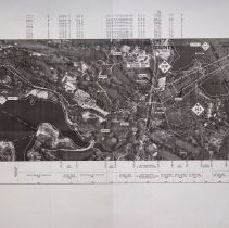
A map of the Algonquin Pipeline Project Phase III (3), which was created by Maritimes & Northeast Pipeline, L.L.C. The map is an alighnment sheet. The the pipeline would run near Kernwood Cove to North River, Salem. The property lines on the map are based on existing mapping and taxmaps. The compilation performed by Coler & Colantonio, Inc. of Norwell MA in the winter of 2000. The wetland delineation was conducted by Earth Tech in the fall of 2000 and spring of 2000 and the date of orthophotography was in May of 1999. The drafting designer; drafting supervisor; design engineer and project manager all signed off on the map on August 25, 2000. The W.O. # 270001 DWG: BB-A-1024 |
Access Conditions |
Restricted to use in Sutton Room or Research Room. |
Physical characteristics |
Three folders and 17 maps. |
Creator |
Maritimes & Northeast Pipeline |
Title |
Algonquin Pipeline Project Maritimes & Northeast Pipeline Phase III, Alignment Sheet. |
Level of description |
Item |
Copyrights |
All copyrights belong to the Peabody Institute Library, Peabody, MA |
Collection |
Local History Resource Center |
Pub Date |
08/24/2001 |
Size |
24" x 35 3/4" |
Subjects |
Danvers (Mass.)--Maps Salem (Mass.)--Maps |
Parent ObjectID |
2015.36.2 |