
Archive Record
Images
Metadata
Catalog Number |
2003.59.1 |
Object Name |
Map |
Scope & Content |
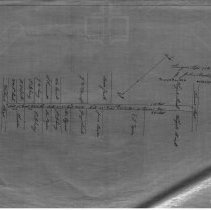
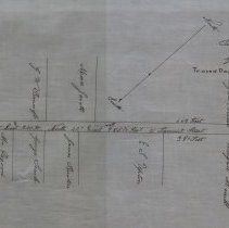
Plan of street between Walnut and Tremont Street. The street appears to be the present day Mount Vernon Street. This is a duplicate of the orginal. It is unknown what happened to the original. The land was surveyed by Joshua Buxton, Jr. on September 17th, 1858. The map was traced from the original by George A. Barnaby in March of 1928. |
Access Conditions |
Restricted to use in Sutton Room or Research Room. |
Physical characteristics |
Starched Linen Map |
Creator |
George A. Barnaby |
Title |
Plan of street between Walnut and Tremont Street. |
Level of description |
Item |
Copyrights |
All copyrights belong to the Peabody Institute Library, Peabody, MA |
Collection |
Local History Resource Center |
Pub Date |
1858 |
Size |
28 x 18" |
Parent ObjectID |
2015.36.2 |