
Archive Record
Images
Metadata
Catalog Number |
2003.32.1.B |
Object Name |
Map |
Scope & Content |
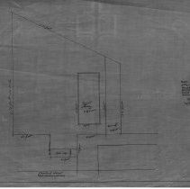
Map showing the property on Chestnut Street and appears to show the property at or near where Saint John's Catholic Church is. The map does look unrelated to the High School House Plan, it was rolled inside it when found. This is a duplicate of the orginal. It is unknown what happened to the original. The land was surveyed by Charles A. Putnam on September 26th, 1889. The map was traced from the original by George A. Barnaby in April of 1928. One 28 x 18" Starched Linen Map. Plan No. 48 Sheet 3 |
Access Conditions |
Restricted to use in Sutton Room or Research Room. |
Physical characteristics |
Starched Linen. |
Creator |
George A. Barnaby |
Title |
Plan of Property on Chestnut Street. |
Level of description |
Item |
Copyrights |
All copyrights belong to the Peabody Institute Library, Peabody, MA |
Collection |
Local History Resource Center |
Pub Date |
Unknown |
Size |
28 x 18" |
Subjects |
Peabody (Mass.)--History--Map(s) Peabody (Mass.)--Churches |
Parent ObjectID |
2015.36.2 |