
Archive Record
Images
Metadata
Catalog Number |
2002.731.2 |
Object Name |
Map |
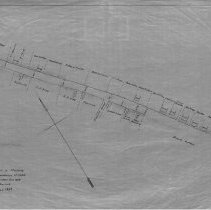
Scope & Content |
Plan of a portion of Lowell St. in Peabody showing the proposed widening. The survey was done in June of 1869 by Charles A. Putnam and the map was traced on January of 1928 by George A. Barnaby. Proporities include Kendall Osborn; Louis Pray; Mrs. Fairfield; John Heylingurg; King Estate; Joseph Lord; J.P. King; F.T. Johnson; George Walton; Robert Emmerson; N.C. Page; John Dodge; Miles Osborn;Josiah Butman; Peter Eaton; Horatio Bodge among others. The two streets on this map beyond Lowell is Franklin Street and Kosciusco Street. One 28 x 18" map showing widening of Lowell Street and includes names of residents. Plan No. 7 Section B |
Access Conditions |
Restricted to use in Sutton Room or Research Room. |
Physical characteristics |
Starched linen map |
Creator |
George A. Barnaby |
Title |
Plan Of Portion of Lowell St. In Peabody Showing the Proposed Widening Of Same |
Level of description |
Item |
Copyrights |
All copyrights belong to the Peabody Institute Library |
Collection |
Local History Resource Center |
Pub Date |
1869, 1928 |
Size |
28 x 18" |
Subjects |
Peabody (Mass.) - Maps |
Parent ObjectID |
2015.36.2 |