
Archive Record
Images
Metadata
Catalog Number |
2002.773.1.B |
Object Name |
Map |
Scope & Content |
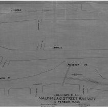
One 28 x 18" starched linen map showing the route of the location of the Naumkeag Street Railway. The map shows the railway running down Lowell and Main Street. The railway intersects with Endicott Street; Crowninshield Street; Franklin Street; Chestnut Street; Sawyer Street; Kosciusko Street and Foster Street. The railway does go though Peabody Square. Plan No. 21 -- Sheets No. 4,5,6 The survey was doen by Arthur Hodges a civil engineer on May 1, 1885 and the map was traced on April of 1928 by Geroge A. Barnaby. |
Access Conditions |
Restricted to use in Sutton Room or Research Room. |
Creator |
George A. Barnaby |
Title |
Location of the Naumkeag Street RailWay In Peabody, Mass. |
Level of description |
Item |
Copyrights |
All copyrights belong to the Peabody Institute Library, Peabody, MA |
Collection |
Local History Resource Center |
Pub Date |
1885 |
Size |
28 x 18" |
Subjects |
Peabody (Mass.)--History--Map |
Parent ObjectID |
2015.36.2 |