
Archive Record
Images
Metadata
Catalog Number |
2016.17.1.B |
Old ID number |
2004.284.3 |
Object Name |
Map |
Scope & Content |
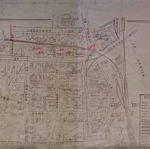
Map of downtown Peabody from the circa 1890s that is similar to the Sanborn Insurance Maps. This maps shows the streets, and locations of buildings and houses along with who owned them at the time. The map also provides the house numbers of the area. This photocopy of the original map shows: Lowell Street; Central Street; Mill Street; Walnut Street; Wallis Street; Main Street; Park Street; Elliott Place; Spring Street; Sanger Place; Winter Street; Oak Street; Foster Street; Church Street; Railroad Avenue and Chestnut Street. This section of the map also provides the reference for makrings on the map such as: brick buildings; wood; brick & wood building; ston; iren; barn, stable or shed; green house; water pipes and fire hydrants; railroad crossing at grade; railroad under public road; railroad over public road; sewer; steam railroad; street; railway; adjoining plate. |
Access Conditions |
Restricted to use in Sutton Room or Research Room. |
Physical characteristics |
Blue print maps. |
Creator |
Unknown |
Title |
Central Peabody, c. 1890's. |
Level of description |
Item |
Copyrights |
All copyrights belong to the Peabody Institute Library, Peabody, MA |
Collection |
Local History Resource Center |
Pub Date |
c. 1890's |
Size |
11" x 17" |
Parent ObjectID |
2015.36.2 |
Relation |
Show Related Records... |