
Archive Record
Images
Metadata
Catalog Number |
2003.351.15 |
Object Name |
Map |
Scope & Content |
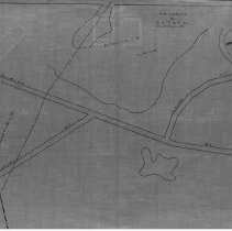
Map of one of of thirty three maps of location of poles throughout Peabody by the New England Telephone & Telegraph Company. This maps shows the location of poles for: Lake Street; Newbury Street; Locust Street and Suntaug Lake. The boundary for Peabody and Lynnfield can be seen on the map. In addition, the South Reading Branch B & M Railroad and Boston & Maine Railroad are represented on the map. This is a duplicate of the orginal. It is unknown what happened to the original. The land was surveyed by New England Telephone & Telegraph Company on December 8, 1890; June 26, 1906 & October 6, 1910. The map was traced from the original by George A. Barnaby in December of 1928. Plan 169, No. 15 For further information see 2003.351.1 |
Access Conditions |
Restricted to use in Sutton Room or Research Room. |
Physical characteristics |
Starched Linen Map |
Creator |
New England Telephone and Telegraph Company |
Title |
The New England Telephone and Telegraph Company Of Massachusetts. Line of Poles in Town of Peabody. |
Level of description |
Item |
Copyrights |
All copyrights belong to the Peabody Institute Library, Peabody, MA |
Collection |
Local History Resource Center |
Pub Date |
1911 |
Size |
18" x 28" |
Subjects |
Peabody (Mass.)--History--Map(s) |
Parent ObjectID |
2015.36.2 |
Relation |
Show Related Records... |