
Archive Record
Images
Metadata
Catalog Number |
2016.83.50 |
Object Name |
Map |
Scope & Content |
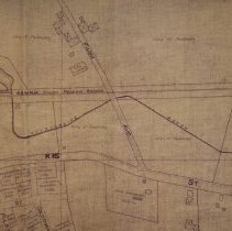
Map of Peabody created in 1931. Streets include: Farm Avenue Lynnfield Street Goldthwaite Avenue Hillcrest Strreet Appleton Street Felton Avenue Bryant Street Pulsifer Avenue Right of Way Property: Boston & Maine Railroad Maurice J. LeBlane Blanche C. Campbell Hannah Doodge City of Peabody Elvira F. Cares Margaretta Watts Albert Tufts Earl C. Putnam Joseph S. Kite Sophia Kotraski 24.01 acres John Swinavski Walter H. Bonnelli Carmello Piccitto, Tr. James L. Dowling Katherine Smith Samuel P. Melville Walter S. Lovejoy Harry P. Chadwick J. Harold Ferguson Sarah L. Chase Maurice L. Ramsdell Elizabeth Waycocate Leander E. Joy Mary J. Swasey George P. Gartland Christina Gartland Sarah Bagley John M. Whelton John Blevins J. Edwin Burdette Mary Perry Margaret E. Gough Clifton E. Hall Michael R. Connolly Henry O. Swan Walter S. Morse Joseph Ohlson Sewall Hart Antoio Dephillipo Vito DePhillipo Melvina Bourgo George E. Dovey Daniel H. Bryant Estate William Little Samuel T. Richings Eastman Gelatine Corp. City of Peabody K 15-16 L 14-15 |
Access Conditions |
Property of the Peabody Institute Library, Peabody, MA |
Creator |
Unknown |
Title |
Map of Peabody |
Level of description |
Item |
Copyrights |
COPYRIGHT UNDETERMINED The copyright and related rights status of this Item has been reviewed by the organization that has made the Item available, but the organization was unable to make a conclusive determination as to the copyright status of the Item. Please refer to the organization that has made the Item available for more information. You are free to use this Item in any way that is permitted by the copyright and related rights legislation that applies to your use. NOTICES Unless expressly stated otherwise, the organization that has made this Item available makes no warranties about the Item and cannot guarantee the accuracy of this Rights Statement. You are responsible for your own use. You may find additional information about the copyright status of the Item on the website of the organization that has made the Item available. You may need to obtain other permissions for your intended use. For example, other rights such as publicity, privacy or moral rights may limit how you may use the material. |
Collection |
Local History Resource Center |
Pub Date |
1931 |
Size |
30 x 42.5 inches |
Subjects |
Peabody (Mass.)--History--Map(s) Peabody (Mass.)--Streets |
Parent ObjectID |
2015.36.2 |