
Archive Record
Images
Additional Images [1]
Metadata
Catalog Number |
2004.330.1 |
Object Name |
Map |
Scope & Content |
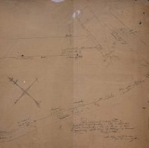
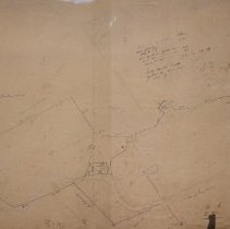
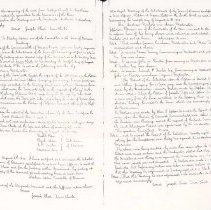
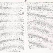
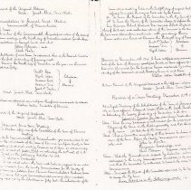
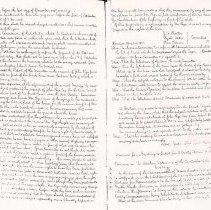
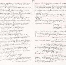
Maps of the farm of Richard Crowninshield, between Reading Road and Road toward North Danvers. The map is on both sides. One with Reading Road, now present day Lowell Street, shows area between Crowninshield farm, where the woolen mills were to the road leading to North Danvers, now present day Central Street. Shows proposed road. Has many notes written along border. On other side, appears to be map of unidentified area in Salem. Judge White of Salem was one of the dignitaries invited to the Danvers Centennial Celebration parade in 1852. James Andrews and William B. Parker were also from Salem. The river mentioned in map could be Forest River or the North River. Notes on map appear to be list of recent petitions, the Orne's Point in the notes is in Salem and may relate to the map on the other side. Town Reports from 1840 to 1841, regarding Edward Crowninshield's request to the town on behalf of his brother Richard. "A Report of the Selectman upon the petition of Edward Crowninshield, and Others, praying for a town way, and the accompanying papers were read by the Moderator, and on a motion made by Stephen Upton, Esq., it was voted that the petition of Joseph Tufts and others praying for a new way from the lane, so called to the Reading Road by Crowninshield's Factory." "The Petition of Edward Crowninshield and others to the Selectman praying for a town way from Gardner's Bridge to the Crowninshield Factory to the Reading Road. . . ." |
Access Conditions |
Restricted to use in Sutton Room or Research Room. |
Physical characteristics |
Paper map, drawn in ink. |
Creator |
Unidentified at present |
Title |
Plan of Farm of Richard Crowninshield, between Reading Road and Road toward North Danvers. |
Level of description |
Item |
Copyrights |
All copyrights belong to the Peabody Institute Library, Peabody, MA |
Collection |
Local History Resource Center |
Pub Date |
1841 |
Size |
20" x 27" |
Subjects |
Peabody (Mass.)--History--Map(s) Peabody (Mass.)--Streets |
Parent ObjectID |
2015.36.2 |