
Archive Record
Images
Metadata
Catalog Number |
2002.764.1 |
Object Name |
Map |
Scope & Content |
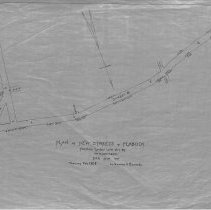
Proposed streets called Street A and Street B between North Street, Salem and Tremont Street, Peabody. No houses or other property are listed on this map. One 28 x 18" Starched Linen Map. Plan No. 12 |
Access Conditions |
Restricted to use in Sutton Room or Research Room. |
Creator |
George A. Barnaby traced map February 1928 |
Title |
Plan of New Streets in Peabody Through Lands Laid Out by Wm. D. Northend. |
Level of description |
Item |
Copyrights |
All copyrights belong to the Peabody Institute Library |
Collection |
Local History Resource Center |
Pub Date |
1928 |
Size |
28 x 18" |
Subjects |
Peabody (Mass.)--History--Map Peabody (Mass.)--Streets |
Parent ObjectID |
2015.36.2 |