
Archive Record
Images
Metadata
Catalog Number |
2002.772.1 |
Object Name |
Map |
Scope & Content |
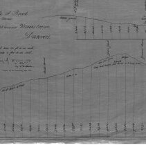
One 28 x 18" starched linen plan and survey of Wilson's Hill in 1845 for the land and grade of road leading to Gardner Street. The road goes between N [ ? ] Josselin's house and Wilson's Corner, Danvers. F.W. Lander is presumed to have done the survey in 1845 and George B. Barnaby traced the map in January of 1928. Plan No. 20 |
Access Conditions |
Restricted to use in Sutton Room or Research Room. |
Creator |
George A. Barnaby |
Title |
Plan of Road between N (?) Josselin's house and Wilson's Corner, Danvers. |
Level of description |
Item |
Copyrights |
All copyrights belong to the Peabody Institute Library, Peabody, MA |
Collection |
Local History Resource Center |
Pub Date |
1845 |
Size |
28 x 18" |
Subjects |
Peabody (Mass.)--History--Map |
Parent ObjectID |
2015.36.2 |