
Archive Record
Images
Metadata
Catalog Number |
2003.369.1.K |
Old ID number |
2003.369.11 |
Object Name |
Map |
Scope & Content |
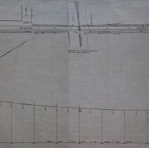
Plan shows location of Street Railway on Newbury Street in Peabody. Map also shows height of street and grade level for railway. The railway would be going doing the middle of Newbury Street and where it connects with Pine Street and crosses over the Boston and Maine Railroad (Salem & Lowell Branch), which was steam powered at the time. The plans were drawn on September 26, 1903 and was approved on November 19, 1903 and approved by the five selectment of Peabody: Andrew N. Jacobs; Richard J. [Unclear]; Patrick J. Martin; George Reynolds and Charles Goldthwait. G.M. Tompson was the civil and consulting engineer who worked on the project. His office was located at 6 Beacon Street in Boston. The map was traced by George A. Barnaby in May of 1929. Plan No. 218 Sheet No. 6 Section No. 2 Total Sheets, 17 |
Access Conditions |
Restricted to use in Sutton Room or Research Room. |
Creator |
G. M. Tompson |
Other Creators |
George A. Barnaby |
Title |
Location of the Maplewood & Danvers Street Railway in Peabody, Mass. |
Level of description |
Item |
Copyrights |
All copyrights belong to the Peabody Institute Library, Peabody, MA |
Collection |
Local History Resource Center |
Pub Date |
1903 |
Size |
28 x 18" / 46 x 71.12 cm |
Subjects |
Peabody (Mass.)--History--Map(s) |
Parent ObjectID |
2015.36.2 |
Relation |
Show Related Records... |