
Archive Record
Images
Metadata
Catalog Number |
2008.50.20 |
Object Name |
Map |
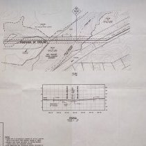
Scope & Content |
A map of the Ipswich Rivercrossing as part of the Algonquin Pipeline Project, which was created by Maritimes & Northeast Pipeline. This is alignment sheet. The civil survey was done by Coler & Colantonio on May 3, 2001 with approximate maximum water depth of 3 feet The carrier pipe to be installed consists of 30" O.D.x 0.618 WT, API 5LX-70, FBE, W/2.75" thick cooncrete coating @ 190 PCF The property lines shown are based on existing mapping, current deeds and possession evidence. DWG: Ipswich_R W.O. 270001 |
Access Conditions |
Restricted to use in Sutton Room or Research Room. |
Physical characteristics |
Three folders and 17 maps. |
Creator |
Maritimes & Northeast Pipeline |
Title |
Algonquin Pipeline Project Maritimes & Northeast Pipeline Phase III, Alignment Sheet. |
Level of description |
Item |
Copyrights |
All copyrights belong to the Peabody Institute Library, Peabody, MA |
Collection |
Local History Resource Center |
Pub Date |
06/21/2001 |
Size |
26" x 42" |
Subjects |
Danvers (Mass.)--Maps Peabody (Mass.)--Maps |
Parent ObjectID |
2015.36.2 |