
Archive Record
Images
Metadata
Catalog Number |
2016.39.1 |
Object Name |
Map |
Scope & Content |
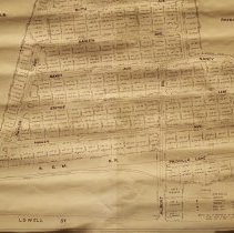
A plan of the Lowell Street subdivision for a plan of land in Peabody for the Center Realty Company. The plan was done by Towers Engineering Co., which was located at 226 Lowis Street in Lynn and the plan was created on April 14th, 1955 and was amended on April 22nd, 1955. The plan looks similar to a pyramid. On the left and right the subdivision is mostly surrounded by the Salem Country Club. On the right the subdivision abuts property owned by Patrick U. Tumelty and F. Oakes. To the South is the Boston & Maine Railroad and a brook. The roads are: Albert Road; Pricilla Lane; Nancy Avenue; Edythe Lane; Raylen; Ruth Avenue; Paul Avenue; Jean Street; Philip Avenue and Lowell Street. There is a note that reads: "All of perimeter to north side of R.R. taken from plan by Osborn Palmer Surveyor dated May 12, 1935 and filed DK 65 PL. 29. |
Access Conditions |
Restricted to use in Sutton Room or Research Room. |
Creator |
Center Realty Company |
Title |
Lowell Street Subdivision Plan of Land in Peabody |
Level of description |
Item |
Copyrights |
All copyrights belong to the Peabody Institute Library, Peabody, MA |
Collection |
Local History Resource Center |
Pub Date |
04/14/1955 |
Subjects |
Peabody (Mass.)--Streets--Subdivsion Peabody (Mass.)--History Peabody (Mass.)--History--Map(s) |
Parent ObjectID |
2015.36.2 |