
Archive Record
Images
Metadata
Catalog Number |
2003.411.1 |
Object Name |
Map |
Scope & Content |
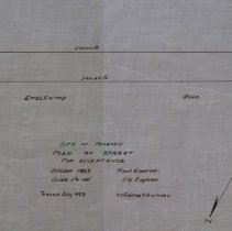
Plan shows Englewood Street being laid out between Margin and Walsh Streets. It should be noted that Englewood Road being laid out on the map does not yet include Kernwood Rd. that is on the other side of Walsh Ave. Frank Emerson the City Engineer, did the survey of the land. It is unknown where the location of the original is. This may was traced by George A. Barnaby in July of 1929. Plan No. 247 |
Access Conditions |
Restricted to use in Sutton Room or Research Room. |
Physical characteristics |
Starched Linen Map |
Creator |
George A. Barnaby |
Other Creators |
Frank Emerson |
Title |
City of Peabody Plan of Street for Acceptance |
Level of description |
Item |
Copyrights |
All copyrights belong to the Peabody Institute Library, Peabody, MA |
Collection |
Local History Resource Center |
Pub Date |
1923 |
Size |
46 x 71.12 cm |
Subjects |
Peabody (Mass.)--History--Map(s) Peabody (Mass.)--Streets |
Parent ObjectID |
2015.36.2 |